
Project Partner: Chloris Geospatial, Summer 2025
Project Summary: Forests provide crucial ecosystem services such as biodiversity preservation, water cycle regulation, and soil protection. Environmental policies and rising carbon markets have incentivized reforestation projects worldwide. However, the value of forests is difficult to be quantified in actual numbers. Currently, the market is in need of quick and accurate estimates of forest regrowth.
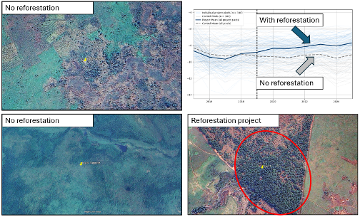
Luofan partnered with Chloris Geospatial, a for-profit company, to explore new methods to estimate the carbon accumulation of reforestation projects by combining multiple satellite datasets. A recent carbon accounting method (VM0047) requires that, to be certified for carbon credits, reforestation projects must prove “human involvement” facilitates ecosystem restoration. To this end, control sites with similar status are selected to compare with reforestation project sites.
Luofan tested a series of remote sensing datasets over various regions in Central Africa. While the project is still ongoing, our recent models may be used to evaluate reforestation projects accurately and promptly. The new products have the potential to contribute to better global carbon crediting.
Project Deliverables:
- Develop a defendable method to track forest status and biomass accumulation using satellite and in-situ data to evaluate reforestation projects.
Watch Luofan’s URBAN Internship Lightning Talk here.