Research Activities
REMOTE SENSING OF URBAN AIR QUALITY |
BIOSPHERE-ATMOSPHERE INTERACTIONS |
Remote Sensing of Urban Air Quality
This research focuses on understanding and improving how we monitor air quality, especially in complex urban and coastal environments. We aim to accurately quantify the distribution of pollutants that are harmful to human health and understand the connections between atmospheric chemistry and meteorology in urban environments.
The Challenge:
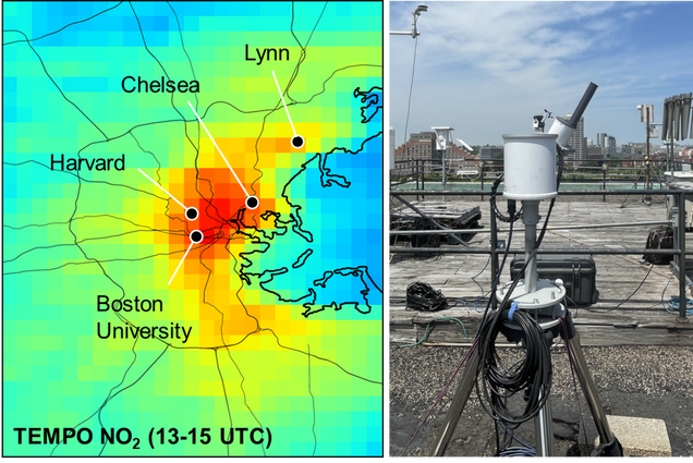
Traditional air quality monitoring networks often have significant gaps. These networks are typically sparse, designed for regulatory compliance, and may not capture the full picture of pollution at the community level, especially in complex environments like coastal cities. In places like Boston, prevailing assumptions about air quality can be biased by where monitors are placed. For example, our work has shown that existing networks can miss high ozone events that occur in inland suburbs on sea breeze days, underestimating the role of local pollution. Sea breezes, common in coastal areas, create unique challenges by trapping and recirculating locally-emitted pollutants, leading to high spatial variability in secondary pollutants like ozone. This means that a person’s exposure to harmful pollutants can change dramatically over short distances.
A New Era of Observations:
To overcome the limitations of traditional monitoring, we leverage advanced remote sensing technologies, including data from new geostationary satellites like TEMPO and our own network of ground-based instruments called Pandora spectrometers. We combine these observations with chemical transport modeling of the urban environment.
- Satellite observations: Satellites like TEMPO provide a revolutionary view of air pollution, offering hourly coverage over North America. This allows us to map the daily evolution of pollutants like nitrogen dioxide (NO₂) and formaldehyde (HCHO), and track phenomena like the movement of pollution fronts in response to meteorological forcings. Our research uses these satellite observations to identify pollution hotspots that may be missed by ground monitors and to understand how meteorological conditions, such as sea breezes, influence regional air quality.
- Ground-Based Remote Sensing with Pandora: Our group operates a network of Pandora instruments in cities like Boston and Salt Lake City. These instruments act as a crucial “reference” on the ground, helping us validate and interpret satellite data. Pandora instruments can measure the total amount of a pollutant in the atmosphere (the “total column”) and provide information on its vertical distribution. We use them to:
- Evaluate satellite performance across different urban and meteorological situations.
- Study the complex relationship between pollution in the atmospheric column (seen by satellites) and the pollution we breathe at the surface.
- Map pollution across the city by scanning the sky in multiple directions, helping us to triangulate emission sources and track plumes.
Recent Projects and Key Results:
- Improving satellite data quality:

Identifying sources of bias in the TEMPO retrieval, and assessing the quality of diurnal patterns retrieved from space. A major focus of our work is to understand and improve the accuracy of satellite retrievals. The conversion of a satellite’s raw measurement (a “slant column”) to a vertical column of a pollutant requires an “air mass factor” (AMF), which depends on assumptions about the atmosphere and surface. Our ground-based Pandora measurements have revealed significant challenges with these assumptions. For instance, in Boston, we found that the TEMPO satellite product showed a large, artificial variation in morning NO₂ levels that was not real. This was caused by uncertainties in how the satellite retrieval accounts for changing viewing angles and surface reflectivity throughout the day. By carefully analyzing the satellite’s direct measurements, we showed that the satellite is capable of capturing real-world pollution patterns, but this information can be lost or distorted by the current retrieval process.
- Mapping Urban Pollution from the Ground Up:
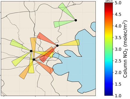
Mapping nitrogen dioxide column variability within Boston with ground-based remote sensing We have developed innovative experiments using our Pandora network to create detailed maps of NO₂ distribution across Boston. By scanning the sky from multiple locations and in different directions, we can observe how the spatial patterns of pollution evolve throughout the day and under different weather conditions like westerly winds versus sea breezes. This provides a unique view of air quality at a scale that bridges the gap between hyperlocal street-level sensors and large-scale satellite pixels.
- Connecting Air Pollution Aloft to Surface Concentrations: A critical question for public health is how well satellite measurements, which see the entire atmospheric column, represent air quality at the surface. Our research shows this relationship is complex and changes with time of day and weather. On some days, the column and surface levels are well-correlated, but on others, such as during sea breeze events, they can behave very differently. This work is essential for correctly using satellite data to estimate human exposure to pollution.
- Studying Air Quality in Different Urban Environments: Beyond Boston’s coastal climate, we have also deployed our instruments in Salt Lake City to study different air quality challenges, such as extreme wintertime pollution events. In Salt Lake City, we found that TEMPO performs remarkably well, capturing the 2-3x increase in NO₂ during persistent cold air pool events, which trap pollution in the valley.
Ultimately, our group’s work aims to ensure that the next generation of air quality observations from space can be used effectively and accurately to protect public health, inform policy, and advance our fundamental understanding of atmospheric chemistry.
Currently and Previously Funded Projects:
- NASA: Geostationary Ozone Precursors Mapping: Linking Intra-Urban Emissions and Chemistry with Air Quality Policy (ongoing)
- NASA: Multi-Scale Modeling and Remote Sensing of Air Quality in a Coastal Urban Environment (ongoing)
- NOAA: CO2-Air Quality Urban Synthesis and Analysis (“CO2-AQ USA”) Project: Trends & Drivers of Urban Emissions from Past, Present, to Future (completed)
- NASA: Remote Sensing of Surface-Level Ozone Sensitivity to Nitrogen Oxides and Volatile Organic Compounds (completed)
- NASA: Remote Sensing of Surface Air Quality: New Insight into Intra-Urban Variability in Tropospheric NO2 and HCHO (completed)
Biosphere-Atmosphere-Chemistry Interactions
This research focuses on understanding and improving how we simulate fluxes of reactive trace gases between the atmosphere and biosphere, and predict how future changes in land cover and vegetation distribution could impact air quality. We aim to understand how emissions and deposition between terrestrial ecosystems and the atmosphere respond to environmental variables and human management activities.
The Challenge:
The terrestrial biosphere acts as both a source and sink for many reactive trace gases that impact atmospheric chemistry and air quality. Our current ability to model these processes is affected by large uncertainties, and modeling approaches vary widely, resulting in a large range predictions. In some cases, we lack basic agreement on how emissions or deposition fluxes may respond to basic environmental variables like temperature and soil moisture. This compromises our ability to project how air quality may respond to land use and land cover changes, in addition to future climate. It also means we have difficulty quantifying the full impacts of air pollution on ecosystem health and productivity. We hope to advance our predictive capacity of these biosphere-atmosphere-chemistry interactions. Fluxes from agricultural landscapes are particularly important, but poorly observed and therefore weakly constrained in chemical transport models.
GEOS-Chem:

Some of the most interesting and challenging questions about atmospheric composition are unable to be answered by available observations alone. Atmospheric chemical transport models (CTMs) incorporate our best understanding of emissions, chemical mechanisms, transport, and uptake at the surface. We can then use the models to predict atmospheric composition and simulate potential impacts over many temporal scales and across large regions. In our group, we use the GEOS-Chem model extensively. We are interested in improving and validating the representation of biosphere processes and surface-atmosphere exchanges GEOS-Chem, and applying these advances to other chemical transport model approaches.
- Detailed Atmospheric Chemistry: GEOS-Chem incorporates a complex chemical mechanism, including more than 200 chemical species and over 700 reactions, to simulate the chemistry that forms pollutants like ozone and particulate matter from precursor emissions.
- Atmospheric Transport: The model’s simulation of how chemical species move through the atmosphere is driven by assimilated meteorological data from NASA, such as the MERRA-2 reanalysis.
- Emission Inventories: Global and regional inventories are used for anthropogenic emissions (e.g., CEDS), and the model includes online parameterizations for biogenic sources, such as emissions from vegetation and soils. Our research is particularly focused on understanding how field observations and satellite measurements might help constrain biogenic reactive nitrogen emissions from soils and agriculture.
- Atmospheric Deposition: The model accounts for the removal of chemicals to the surface by deposition, comprised of both west and dry deposition processes. Dry deposition in particular can respond dynamically to terrestrial vegetation properties like phenology and canopy density. Our research explores uncertainties in modeling of dry deposition, as well as examining long-term trends in the deposition of nitrogen and ozone to terrestrial ecosystems.
Recent Projects and Key Results:
- Uncertainty in Dry Deposition Modeling:

Interannual variability in O3 stomatal uptake predicted by a simple dry deposition parameterization accounting for changes in meteorology. A major focus of our research is on how pollutants are removed from the atmosphere by ecosystems through a process called dry deposition. The research highlights significant uncertainties in modeling this process, which compromises the accuracy of air quality and ecosystem health projections. We have found that the choice of dry deposition parameterization scheme alone can cause predictions of summertime ozone concentrations to vary widely. Models also struggle to reproduce how dry deposition fluxes respond to environmental extremes like heat and drought. We are developing a framework or “toolbox” to allow for rapid calculations of ozone deposition as a function of different approaches and inputs, to enable researchers to quantify uncertainty and calculate ensemble products. This could be used to identify regional hotspots of deposition and better support ecological assessments.
- Soil and Agricultural Emissions of Reactive Nitrogen:
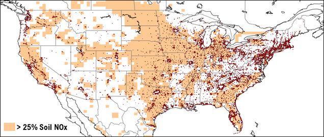
Shading representing regions of the United States where biogenic soil emissions of NOx are more than 25% of the total surface emission budget. Dark red outlines denote designated urban areas. As anthropogenic fossil fuel emissions decline, the role of reactive nitrogen emitted from soils and agriculture is gaining importance. These sources complicate air quality management, and models do a poor job at representing them accurately. We are studying how these emissions may increase in the future due to climate change and land use changes according to different scenarios, with potential implications for quantifying previously unexplored air quality penalties of climate change.
- Impact of Land Use and Land Management: In an era of declining direct anthropogenic emissions, land use and land cover change may become an important human driver of variability in ozone and particulate matter. We have found that even over the last two decades, regional changes in air quality resulting from land process changes could have been about as important as the concomitant changes in direct anthropogenic emission trends. In some cases, the impacts of land use and land management offset emission reductions in other sectors.
FarmFlux Logo - FarmFlux: The FarmFlux mission is a NASA-funded airborne atmospheric chemistry campaign being proposed for the summers of 2026 and 2027, designed to quantify trace gas and particle fluxes over U.S. agriculture. The goals are to both understand the role of agricultural practices on air quality, as well as the impacts of air quality on agricultural productivity. Novel aircraft campaign data will help improve models and support satellite observations of these regions.
Ultimately, our group’s work aims to improve the atmospheric chemistry community’s ability to predict how interactions between Earth’s ecosystems and the atmosphere affect air quality and climate, and how ecosystems may respond to global change.
Currently and Previously Funded Projects:
- NASA: FarmFlux: Agriculture, Ecosystems, Atmosphere (ongoing)
- NSF: Collaborative Research: Understanding Emission Sources and Sinks of Nitrous Acid in North American Forests (ongoing)
- Environment and Climate Change Canada: Modeling and Evaluation of Long-Term Trends in Global Total Atmospheric Deposition (ongoing)
- BU Pardee Center for Longer Range Future: Global Air Quality at the 22nd Century: The Role of Climate- and Land Use-Driven Perturbations to Atmospheric Nitrogen Cycling (completed)
- NSF: CAREER: Air Quality Impacts of Dynamic Forest-Atmosphere-Chemistry Interactions (completed)
- Environment and Climate Change Canada: Measurement-Model Fusion for Global Total Atmospheric Deposition Initiative (completed)