Tiger Team: High Resolution Assessment of Community Health Impacts of Air Pollution
 Video: Webinar on Assessing Health Impacts of Air Pollution at the Community Scale
Air pollution exposure and health risk assessment at the community scale – on the order of kilometers or less corresponding to individual neighborhoods or localities – is of increasing interest to urban planners, environmental health practitioners, and researchers. Watch the recording of this webinar from September, 2018, to learn how scientists and practitioners are using NASA satellite data along with land use information to develop fine scale estimates of PM2.5 air pollution and associated health risks within communities.

Tiger Teams are groups of researchers pursuing short-term, high-impact projects funded by the NASA Health and Air Quality Applied Sciences Team (HAQAST) program. The “Hi-Res” Tiger Team consists of highly experienced senior and junior researchers from academia and public agencies. Members include eleven HAQAST investigators, as well as students, faculty, staff, stakeholders, and outside collaborators in the East Coast working in Boston and New York City, and in the West Coast working in Southern California, Imperial Valley, and the San Francisco Bay Area.
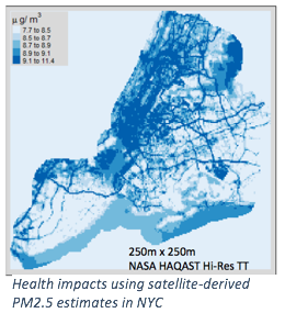
Health departments and urban planners have growing needs for high-resolution data on urban-air-pollution concentrations to quantify existing health burdens at the neighborhood scale; to identify and prioritize exposure-reduction strategies for pollution hot-spots; to track progress in achieving air-quality-related health-improvement goals; and to assess health co-benefits of longer-term carbon-mitigation strategies. To date, however, few data exist to inform these high-priority urban-health objectives. Newly available 1×1 km aerosol optical depth (AOD) retrievals from NASA MODIS satellite products provide opportunities to construct higher-resolution fine particle (PM2.5) spatial fields for intra-urban public-health assessments. The retrievals can also serve as a launching pad for further downscaling using emerging low-cost sensors in conjunction with land-use regression and dispersion models.
This study consists of a number of research aims with the collective goal of utilizing satellite air quality measurements to address a series of community scale air quality issues of stakeholder interest. The work is being carried out across five communities: Boston, New York City, Los Angeles, California’s Imperial Valley and San Francisco Bay Area. The overall goal is to demonstrate existing and in-development techniques to better enable stakeholders in these and other communities to carry out health-based air quality assessments at relevant community scales incorporating measurements from satellites as well as from low-cost air pollution monitoring data. Learn more about the research aims of this project here.
NASA Health and Air Quality Applied Sciences Team (HAQAST)
 HAQAST is a three-year program that was launched in the Fall of 2016 as part of NASA’s Applied Science Program. Research is led by thirteen air quality and public health scientists around the U.S. working in government offices and public and private universities. The team is led by Dr. Tracey Holloway at the University of Wisconsin-Madison, where HAQAST is headquartered.
HAQAST’s ultimate goal is to use NASA’s data and satellites to pursue cutting edge applied research in order to protect public health. To achieve this, HAQAST members and Tiger Teams collaborate with public stakeholders, who help guide our research.
To learn more about HAQAST, you can visit their website, follow them on Twitter, sign up for their newsletter, or consider attending the next public meeting.
Photos retrieved from NASA Earth Observatory. https://earthobservatory.nasa.gov/