Shape-Up
Shape-Up is a platform to help communities prevent gun violence by improving physical spaces. The Shape-Up algorithm learns what a high-risk location looks like in a particular city, using big data and machine learning. The algorithm analyzes aerial imagery to capture urban form; data on locations (e.g., parks, vacant lots, liquor stores) that play important functions; and demographic data to measure social disadvantage. The algorithm generates Shape-Up Scores of 1-10 for every single block in a given city. These scores predict the overall risk of gun violence at a particular location, with predictive accuracy that outperforms traditional crime prediction approaches. They also measure the potential for reducing risk by addressing form, function, or disadvantage.
Shape-Up Scores are designed to inform community discussions about how best to improve neighborhood safety. The ultimate decisions must rest on the knowledge and priorities of community residents.
We continue to refine our processes for community-engaged data science because we are committed to the self-determination of the individuals and communities impacted by gun violence and other forms of structural disadvantage. Using funds to improve neighborhood spaces is a partial, but necessary, step to reverse legacies of racialized disinvestment that contribute to violence. Reinvesting in neighborhood safety is consistent with calls to #FundPeace.
Current Shape-Up partners:
Portland, OR: We’re working with Portland’s Community Safety Division to identify priority locations and interventions for addressing a recent surge in community gun violence. One particular issue in Portland is traffic: some community members have identified a connection between high volume/high speed driving and recent shootings. A pilot program using barrels to calm traffic showed promising results. Accordingly, our Portland work incorporates traffic-related data. Learn more.
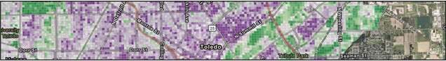
Toledo, OH: We’re working with the Mayor’s Initiative to Reduce Gun Violence, ProMedica Health System, and other local agencies to diagnose risk factors for spatial patterns of gun violence in Toledo. In Toledo, a particular focus is the physical condition of land parcels—we are leveraging a large-scale property survey conducted in 2015 and 2021 by the Lucas County Land Bank.
Related RISE Lab work:
Boston, MA: We’re working with the Boston Public Health Commission’s Youth Organizing Institute to learn from young people (ages 14-19) about the physical and social factors that make a neighborhood safe for them. These youth can see a great deal of risk and protective factors that the Shape-Up algorithm can’t – we’re exploring what community-engaged data science strategies will work best to align these sources of knowledge.
Past Shape-Up partners:
Albany, NY: Demolishing abandoned buildings can reduce gun violence, at least in certain contexts. In 2020, we worked with the City of Albany to help prioritize abandoned buildings for demolition. The Office of Neighborhood Stabilization had identified a list of buildings ready for demolition, but only had the resources to demolish a subset of these. We ran the Shape-Up algorithm for Albany and built a mapping interface (see below). Neighborhood groups reviewed the Shape-Up Scores, along with other information, and decided which buildings to move ahead for demolition. Their final selections were highly correlated with Shape-Up Scores, but also reflected a range of priorities in addition to violence prevention.