News
Free Image Composite Editor by Microsoft
Greetings from Greece!
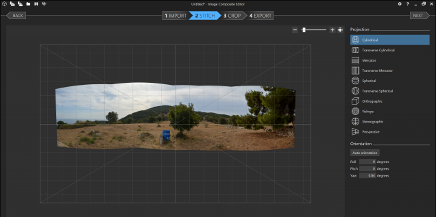
A major part of my dissertation data collection involves photographing viewsheds with my DSLR. Unfortunately, the Nikon DSLR is not equipped to automatically stitch together photographs, unlike some point and shoots. I decided to test several free panoramic image programs today, after my work in the field.
Using the Free Image Composite Editor, I have been able to stitch together up to thirty images at a time. The program will auto detect the overlapping edges, or allow you to select a variety of settings to manually create the panorama. I ran the program about twenty times, and had no issues with the auto detect feature. Most helpful are the projection settings, allowing you to warp the panoramic shot with complex options like orthographic and planar views. Here is an example of an image I created this afternoon at the Kalaureia Sanctuary of Poseidon:
These projections are an excellent resource for those interested in conveying the visual effects of a particular location. Why present a flattened image when you can project it for a three dimensional perspective, as we do with geographic data?
Try the Image Composite Editor here.
Product Review: Open Science Framework
I recently attended an Open Science Framework workshop hosted by Boston University’s Mugar Library. This is a free service provided by the Center of Open Science .
Open Science Framework is a free tool that promotes group collaboration and best data practices, including archiving, storage, version control tracking, and backup. Users can make a profile, and invite other users to collaborate on an individual project. The PI has the ability to limit accessibility privileges for each user; privilege levels will vary for each section of the project. The Open Science Framework structure is intentionally bare, allowing the user to add individual components as needed. These could include, for example, spaces for storing and documenting your datasets, bibliography, or project methodology.
Because the OSF wants to be a malleable tool, any project uploaded to the OSF will sync with other systems, including GitHub, Google Drive, and Dropbox. Project are given substantial storage space; each file uploaded to the OSF can be up to 5 free gigabytes. I experimented with uploading, and did not encounter restrictions in terms of data-type. Do keep in mind, however, that that while your project will be password protected, the system is not encrypted. Most importantly, the OSF is geared towards documenting changes made to the project. For each file or component structure, changes can be made by users, based on their permission level, and the OSF will provide a side-by-side comparison of the current draft and past changes. Changes are color-coded per user.
On the basis of the demonstration given at the workshop, Open Science Framework could be a great choice for digital landscape projects that are in need of a collaborative workspace. Many of us know that when working with complex software packages and massive amounts of data, it is critical that workflows are well documented, and previous versions are archived. Because the OSF provides us with a space to keep track of multiple iterations of a project, we could be better equipped to eventually publicize our methodology, and provide interested scholars with information on any previously encountered challenges. Ultimately, the Open Science Framework could promote collaboration with other, like-minded scholars, and provide a space for archaeologists to see the variety of digital landscape projects that are being implemented across the discipline.
