Agisoft Photoscan
Agisoft Photoscan is a stand-alone software product that performs photogrammetric processing of digital images and generates 3D spatial data
Structure-from-motion photogrammetry is useful for many purposes including creating three-dimensional representations of surfaces, architectural features, excavation units, and portable objects. In Photoscan, users can also create orthophotos and DEMs if the images are acquired through UAVs.
Basic Workflow
Taking Photos
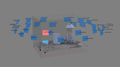
Agisoft Photoscan creates point clouds from photographs by measuring the distances the locations of images to similar points on a surface (object or landscape). Thus, it is important to have multiple overlapping images of the same point on a surface from different angles. Photoscan must also know the GPS location of each image to work effectively. Fortunately, many devices built since 2010 automatically record the GPS locations of each photo taken, however users should check their device settings prior to taking photographs.
Creating Models in Agisoft Photoscan
Once you have your images, you can follow this process to create a point cloud and 3D surface:
- Workflow -> Add Photos (or Add Folder)
- * Optional step: Mask photos (see video tutorials)
- Workflow -> Align Photos
- Workflow -> Build Dense Cloud
- Workflow -> Build Mesh
- Workflow -> Build Texture
This process will provide you with a basic 3D model that you can import into visualization applications such as 3DsMax, Blender, or Unity3D.
For Orthophotos and DEMS, you can build additional models within the “Workflow” section.
To import any of your models: File -> Export
You can save in any number of formats including TIFF (Orthophotos), .ply (for surface models), 3D PDFs, and many more. For a more detailed outline of this process, please view the video tutorials below.
Video Tutorials
- http://www.agisoft.com/support/tutorials/beginner-level/
- https://www.youtube.com/watch?v=VMb4iMDzvj8
- https://www.youtube.com/watch?v=CG11F0RX8WE&list=PL2UsAzNdeUas6e8FUh3Sjpqqcxf2Bzh81
- https://www.youtube.com/watch?v=1iYtjLlm8eI
Masking
You may notice that some points of your model are included that you do not want. This is particularly true for architectural features and objects. To eliminate points in your point cloud that are unnecessary, you need to mask your images prior to aligning your photos.
Video tutorial: https://www.youtube.com/watch?v=-LRbmaUAHR4
In some instances, you can simply adjust the rectangular region that you wish to include after you build the point cloud, but before you build the mesh.
System Requirements
http://www.agisoft.com/downloads/system-requirements/
