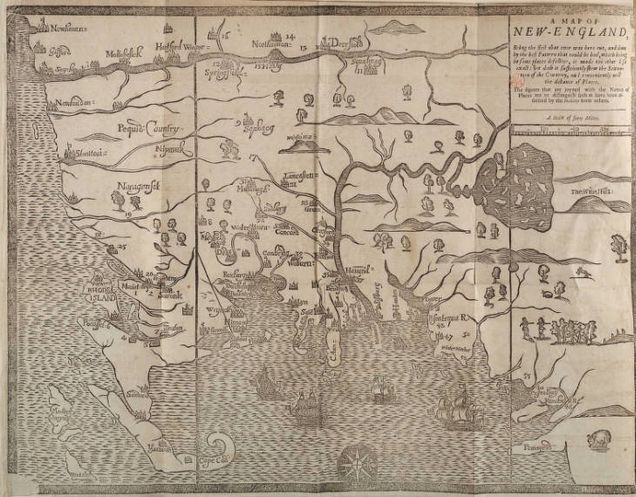
“Map of New-England”

John McLaughlin, Lyda Arevalo, and Theodore Phua
The “Map of New-England” published in the Reverend William Hubbard’s 1677 The Present State of New-England being a Narrative of the Troubles with the Indians in New-England was the first map printed in the New World, and a rudimentary early depiction of the land on which the Massachusetts Bay, Plymouth, and Connecticut colonies lay. Two overarching versions of the Narrative, and thus of the map, exist. The earlier version, printed in Boston, contains a map with the majority of the town names and geographic features labeled correctly, while the later London edition contains numerous misspellings and typographical errors, signifying the disconnect between the English and the inhabitants of their American colonies. The inaccuracies and stylistic variations in Hubbard’s map embody the idealistic Puritan vision for the Massachusetts Bay colonies, building on the written history of the region as providing a visual model of expansion and conflict since 1620.
Hubbard’s map exemplifies a type of map whose use is less topographic or navigational, and more narrative and experiential. Previous maps, even of the New World, contained far more cartographic and topographic detail that would be of great value to explorers. Hubbard’s map placed more emphasis on relative distances between settlements, and its legend contains a disclaimer of possible inaccuracies. Following an older method of mapmaking, Hubbard also depicted each settlement differently which allowed for the unique features of each location to be recognized. This can also be compared to later on in history when maps were made for more usefulness and practicality rather than for their artistry and craftsmanship, indicating a shift in the utilization of maps and the purpose they served.
The most notable feature on the map, and the key to its role as a visual depiction of King Philip’s War, is a system of figures that demarcate the sites of Native American attacks on English villages. The numbers refer to a table in the following pages that explain the “assaults” in greater detail, including casualties and other notable circumstances. However, the narrative presented by Hubbard is incomplete and heavily biased toward the English. There is no mention of the various equally-cruel English attacks on Native American sites, likely due to the map’s unique focus on the relationship between colonists and their God.
While more rational and less righteous than other maps of the region, Hubbard’s map was still highly partial and an incomplete recollection of the war. Its bias served to further glorify the English efforts and incite fear and anger at the Indians. An overwhelming majority of the sites noted on the map provided records of Indian atrocities, while most of the conflicts initiated by the English were purposely left off. The reminder of Indian savagery, further instilled a negative association of Indians among the colonists, which only increased tensions between the groups. Additionally, the few Native American settlements that were represented are marked by shapes from the natural world, such as trees and woods, emphasizing the false idea that they were savages. This resulted and strengthened public opinion to think of Native Americans as a violent group who should be feared while the English were made to be seen as the superior group in the conflict.
Hubbard’s narrative is especially notable for its departure from widespread Puritan belief that the war was a scourge sent by God to punish the decrease in piety among the settlers that other ministers, particularly Increase Mather, spread in their own narratives. Instead, Hubbard made an effort to explain the war using contemporary rational thought, though ultimately connecting it to his underlying belief that the New England colonies were a type of New Israel, a society of biblical importance in whose existence divine Providence had a hand.
The “Map of New-England” deepened the English colonies’ belief that they were unsurpassed and had to maintain, and even elevate, their status in the world. Along with the lack of representation of violence instigated by the English side, the spacing and scale of the map is peculiar in a way that seems too congested at times. This was Hubbard’s way of stating how, to the Puritans’ eyes, there was not enough land in the royal grant and that outside forces, such as Dutch and French colonizers, were limiting English colonies. This can be tied to the vision of the colonies as a “New Israel” and how they believed they had an almighty calling to be the preeminent establishment.