Urban climate
Urban population has been growing fast over the past few decades and the world’s urban population has exceeded 50%. Studying the microclimate of urban environments not only has important energy, water, and health implications, but also help understand the broader impacts of land-use/land-cover changes. However, most of the current numerical models do not have urban land use and/or do not have urban representation. In addition, new studies have found that urban surface and hydrological processes such as vegetation dynamics might be different from those traditionally studies over other environments.
We collect urban micrometeorological data including temperature, specific humidity, wind speed, radiation, turbulent fluxes and so on to understand the unique physical climate of urban areas. We are actively working on understanding the interaction between urban heat islands and heatwaves (Fig. 1, which is taken from Li and Bou-Zeid, 2013). A recent study from our group examined the responses of urban surface energy balance to heat waves using observational data collected in the Beijing metropolitan area (Wang et al. 2015; Li et al. 2015). Currently we are re-examining the role of wind speed changes using the same Beijing dataset.
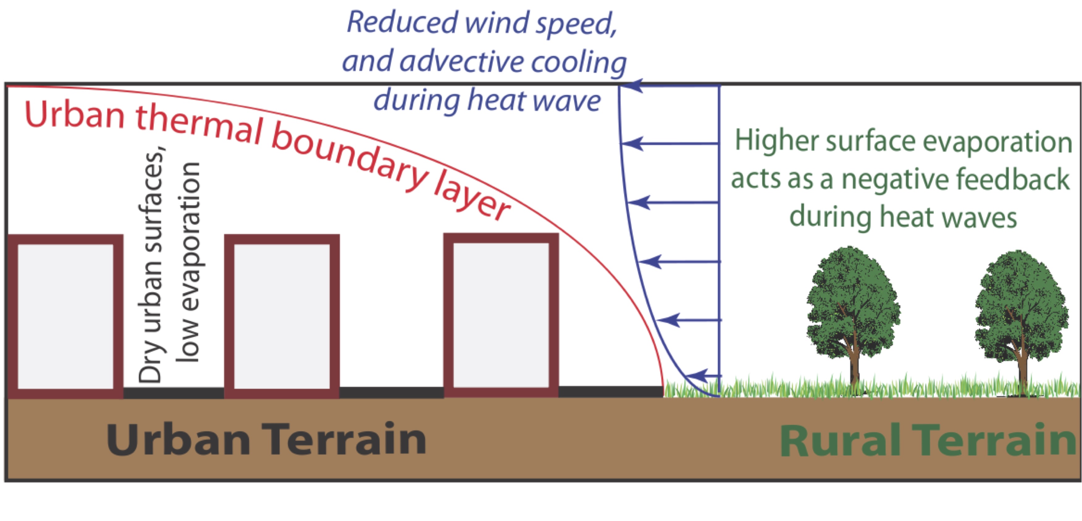
Figure 1: Synergistic interaction mechanisms between the UHI and HWs, which are mainly related to the reduced moisture availability in urban areas and the reduced wind speed during heat waves.
In our group, we also develop parameterizations for urban surfaces (so-called urban canopy models, see Fig. 2) that can be driven by or coupled to large-scale weather and climate models. Fig. 2 shows the LM3-UCM developed by us and coupled to the Geophysical Fluid Dynamics Laboratory (GFDL) land model LM3, which is based on the urban canopy concept and is composed of two major components: a roof component and a canyon component. These two components do not interact with each other directly; instead, they communicate with the bottom atmospheric layer through which they interact with each other. The canyon component includes the walls, the impervious surface at the ground, the pervious surface at the ground (i.e., soil), and the vegetation above soil. These are called subcomponents of the urban canyon hereafter. All of these four subcomponents communicate with the canopy air in the urban canyon, through which they interact with each other and also the atmosphere. Currently we are using the LM3-UCM, in together with GFDL’s HiRAM, to study the impact of urbanization over the Continental United States. We are also improving many aspects of the LM3-UCM for example how it handles snow.
We also use the Weather Research and Forecasting Model (WRF) extensively. We coupled the Princeton Urban Canopy Model to WRF to study urban climate in the Baltimore-Washington metropolitan area (Li and Bou-Zeid 2013; Li et al. 2013; Li and Bou-Zeid, 2014) and the New York city (Ramamurthy et al. 2016). We also developed a mosaic approach into WRF to parameterize the surface heterogeneity effect (Li et al. 2013). In particular, we are combining these numerical tools with other approaches to assess different urban heat mitigation and adaptation strategies (Li et al. 2014; Yang et al. 2015).
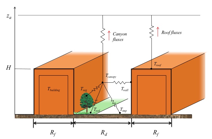
Figure 2: The design of LM3 urban canopy model . za is the height of the first level in the atmospheric model; H is the averaged height of buildings; Rf is the roof width and Rd is the canyon width. Troof is the roof surface temperature; Twall is the wall surface temperature; Tbuilding is the temperature of the building interior; Tcanopy is the canopy air temperature within the urban canyon; Tveg is the vegetation temperature; Tsoil is the soil surface temperature; Timp is the impervious surface temperature.